Posted in Seaside Scenes, Trips at 12:00 on 30 June 2026
Bamburgh from Bamburgh Castle:-

1930s House, Bamburgh, from castle, the leftmost house in the photo. Pity it doesn’t still have its Critall Windows:-

Martello Tower at Bamburgh (Lindisfarne Castle in distance):-

Farne Islands From Bamburgh Castle:-

No Comments »
Posted in Art Deco, Seaside Scenes at 12:00 on 2 May 2026
See previous posts of Moderne and Art Deco buildings in Arbroath.
Art Deco pillars at Victoria Park entrance :-

Sea and wall at Arbroath:-

Arbroath Harbour:-

No Comments »
Posted in Sculpture, Seaside Scenes, Trips at 16:00 on 1 September 2025
Portsoy is a delightful small fishing village on the Moray coast, with what looked like three harbours. It was a warm day and many children and adults were sporting in the shallowest one of them.
Being picturesque, Portsoy has featured in several films and TV series.
This sculpture of a dolphin overlooks the harbours and the sea:-

This old window space in what is now a free-standing wall framed the Moray Firth coast beyond:-

No Comments »
Posted in Seaside Scenes, Trips at 12:00 on 27 August 2025
The towns of Macduff and Banff lie on either side of the Deveron estuary as the River Deveron flows into the Moray Firth. This is Macduff as seen from Banff. The tower on the hilltop is Macduff’s War Memorial but I didn’t get across to photograph it.

Macduff with Banff Harbour in foreground:-

No Comments »
Posted in History, Scenery, Seaside Scenes, Trips at 12:00 on 21 January 2023
Wideford Hill Chambered Cairn, Orkney was one of the ancient sites in the Orkney Islands we didn’t visit in 2017. We tyook it in in June last year.
The approach is up a very steep – and winding – farm road till you reach the car park (grandiose description for two parking spaces) from which you can look down to Kirkwall. The photo also shows some of the road:-

There is a view of Scapa Flow from there too:-

A notice at the car park said the chambered cairn was about half a mile away on a path round the hill. It was much longer than that.
You can see me walking the path here in a photo taken by the good lady. As you can see the cairn is nowhere in sight and we had been walking for about twenty minutes by this time:-

Cairn from path. To the left you can see the box in which the key to the entrance is kept and the information board:-

Information board:-

Original entrance (now gridded off):-

Cairn from above. The modern entrance is the blue square on its top

No Comments »
Posted in Seaside Scenes, Trips at 12:00 on 2 January 2023
The previous time we visited the Brough of Birsay see here and here, the rain started to come in horizontally so we cut things short.
In June this year the weather was much more amenable.
On the way up we had stopped off at Marwick Head again.
Hoy from Marwick Head, Old man of Hoy just visible poking up at right hand end of island:-

Marwick Head from Brough of Birsay, Kitchener Memorial standing out on Marwick Head:-

Mainland Orkney from Brough of Birsay:-

Viking ruins lie close to the causeway from the mainland:-


This time we were able to stroll to the lighthouse:-
Stevenson Lighthouse, Brough of Birsay from path across the brough:-

Close up:-

From northwest:-

From South:-

1 Comment »
Posted in Kirkcaldy, Seaside Scenes at 12:00 on 11 October 2021
In June we took a walk along the seashore of the Firth of Forth from Kirkcaldy towards Seafield Tower. There’s always some wildlife around.
This cormorant was sunning itself against the background of old sea wall blocks:-

Panorama of rocks and seals:-

Basking seals:-

On the way back the tide had come in a bit:-


“Do not disturb” sign. It’s a bit sad that there is felt to be a need to put up a sign like this:-

Video:-

On this video you can hear the seals’ howls:-

No Comments »
Posted in Bridges, Norway Cruise, Seaside Scenes, Trips at 12:00 on 30 June 2021


This one shows the ship we were travelling on (extreme right):-

Close up on lake with fountain:-

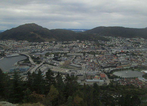
A road bridge in central Bergen from Mount Fløyen:-

Part of Bergen with sea inlets beyond:-

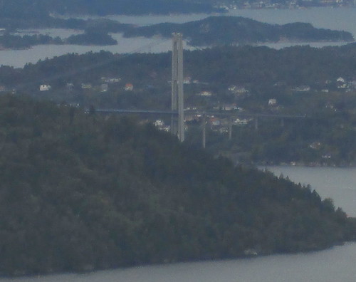
A distant suspension bridge (photo is fuzzy due to zoom function.) Due to its sovereign wealth fund – a legacy of the oil boom – Norway is festooned with infrastructure like this:-
No Comments »
Posted in Architecture, Seaside Scenes, Trips at 12:00 on 18 July 2020
On the way back up from Northeast England last June we took a trip over the causeway (having looked up the tide-tables beforehand) to Lindisfarne, or Holy Island, a place I’d always wanted to visit but somehow had never seemed to find the time before.
It’s an odd experience driving over the causeway – it feels quite long – but the trip was worth it. There was more to Lindisfarne than I’d imagined. Not just the castle and Priory.
Lindisfarne Castle from Approach Road:-

Closer view:-

From the road there’s a good view over the sea to Bamburgh Castle:-

I thought the objects in the next photo were a bit odd, but obviously with some age to them. Only when I got home and looked them up did I find they were Guile Point obelisks and lighthouse. (When lined up the obelisks indicate the safe channel into Lindisfarne harbour.) As seen from Lindisfarne:-

They can be seen again in the background here beyond Lindisfarne’s foreshore with these wooden stumps:-

There is a small village on the island (where lie the remains of Lindisfarne Priory) and a harbour.
Lindisfarne Harbour, Village and Priory from road to Castle:-

No Comments »
Posted in Seaside Scenes, Trips, War Memorials at 12:00 on 27 October 2019
Isle of Whithorn is not to be confused with Whithorn. It is about three miles further south and is one of the most southerly villages in Scotland. The locals refer to it simply as, “the Isle.” It is said to be the place at which St Ninian first made landfall in Scotland.
Harbour. This is where the Drummullin Burn enters the Solway Firth:-

A chapel dedicated to St Ninian was erected here in the 13th century. Its ruins lie very close to the sea.


The village has a War Memorial to the right of the road entering it. A Celtic Cross on a square plinth. Great War names here:-

Dedications, ‘In honour of the men from the village and district who fell in the Great War 1914-1918. “Lest We Forget.” 1939-1945,’ and World War 2 names:-

Edited to add: I meant to say above that the Isle was where part of the cult horror film The Wicker Man was filmed.
No Comments »
