Posted in Fife, Seaside Scenes, Shipping at 12:00 on 6 August 2018
HMS Queen Elizabeth is the Royal Navy’s latest aircraft carrier. (That’s the one there’s not enough money to fit out with any aircraft.)
She sailed out from her fitting out at Rosyth in the Firth of Forth for her sea trials in June 2017. We happened to be in Cellardyke, Fife that day and caught a glimpse of her near the Isle of May.
HMS Queen Elizabeth (yacht in front) and the Isle of May from Cellardyke Harbour:-

HMS Queen Elizabeth and Isle of May closer view:-

HMS Queen Elizabeth closer view:-

Isle of May:-

HMS Queen Elizabeth and another ship:-

No Comments »
Posted in Seaside Scenes, Trips at 12:00 on 24 July 2018
Not quite the farthest northeast point of the British mainland (see previous post) John O’Groats is, though, the furthest northeast settlement in Scotland.
There’s almost nothing there though, which does mean it’s thankfully mostly unspoiled.
Well, a small harbour, from which there are boat trips (foot passengers only) to the island of Stroma, and I think Orkney:-

A hotel:-

The signpost – very difficult to photograph without a body in the way – though they don’t all wear silly hats:-

This view inland also shows in the background the shop at the site:-

There’s also a sculpture with three intersecting curved metal strips to represent the local nomadic boulders the information board shown below explains. There were children playing on it though so I didn’t photograph the sculpture itself:-

No Comments »
Posted in Seaside Scenes, Trips at 20:00 on 23 July 2018
Before heading back south from Thurso I’m nipping back to Duncansby Head, the northeasternmost tip of Scotland (and the UK) which is not, as most people might think, John O’Groats. Duncansby Head is a few miles eastward along a one-track road.
As we had factored in possible traffic delays we had an hour or so’s grace before the ferry to Orkney and so took in the Head.

Cliffs and an inlet:-

The cliffs are home to lots of seabirds:-

As you might expect there’s a lighthouse at the land’s end:-

Just to the south of the head are these rocks sticking up out of the sea. They’re known as the Duncansby Stacks:-

On the way across to Orkney on the ferry I took this photo of Duncansby Head from ten or so miles away in the Pentland Firth:-

No Comments »
Posted in Seaside Scenes, Trips at 12:00 on 18 July 2018
Dunnet Head is the northernmost point of the Scottish mainland and hence of Britain.
Dunnet Head from distance, from a side road off the A 836:-

Cliffs at Dunnet Head:-

Lighthouse, Dunnet Head:-

Dunnet Head Lighthouse Foghorn, island of Hoy in background:-

Lighthouse and foghorn:-

Lighthouse Information Board:-

Lighthouse and Pentland Firth:-

Cliffs again:-

Hoy from Dunnet Head:-

Pentland Firth and Hoy from Dunnet Head:-

The Old Man of Hoy is just visible in this zoom (and in the previous photo if you squint a bit):-

No Comments »
Posted in Seaside Scenes, Trips at 12:00 on 14 July 2018
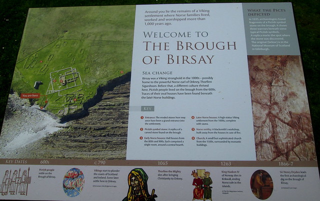
The Brough of Birsay is an island just off the north-east coast of mainland Orkney. I blogged here about the causeway you have to cross to access the island.
It is also home to some archæological remains (as well as a Stevenson lighthouse which we didn’t visit.) The weather was fine when we walked across the causeway to the island but while we were there it started to rain and the wind was so strong the rain was coming in horizontally, so discretion prevailed over perseverance. Even so by the time we got back to the car we were thoroughly drookit.
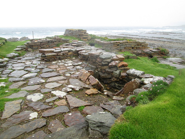
There was some nice geology just where the path from the causeway meets the brough proper.
The archæology on the brough comes from three distinct eras. First there was some Pictish occupancy. However this Pictish symbol stone is a replica, unfortunately. (Though there was such a stone found on the brough.)
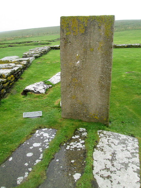
There is a better photograph of the symbol stone on Historic Scotland’s Birsay webpage if you click through the pictures.
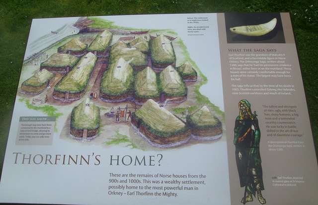
As the information board says there was later Norse – in two phases – and ecclesiastical building on the island.
Remains of Norse houses:-
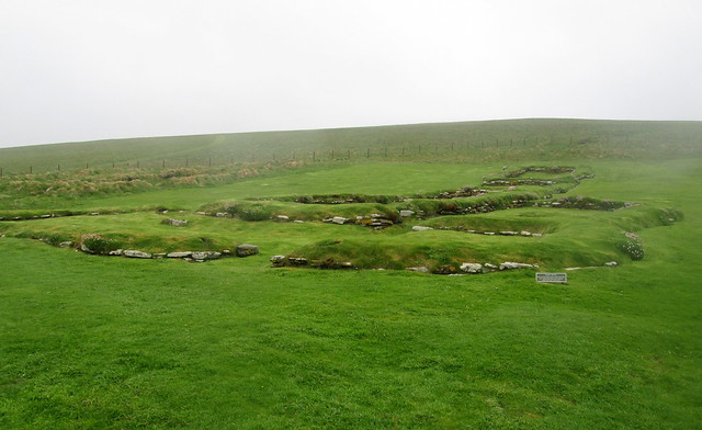
A later Norse house:-
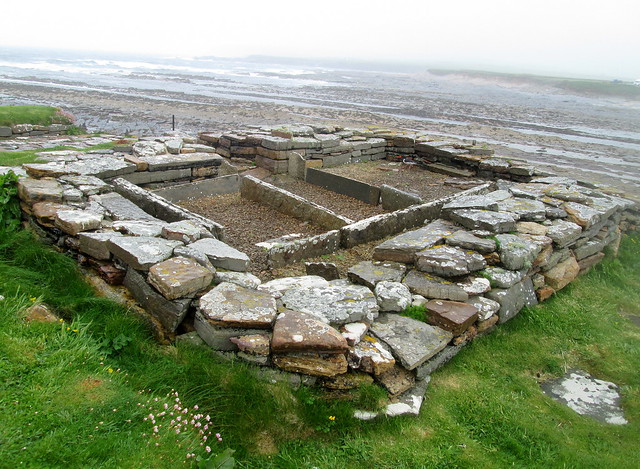
Another later Norse house:-
Birsay may have been the home of Thorfinn the Mighty.
2 Comments »
Posted in Architecture, Fife, Seaside Scenes at 12:00 on 30 May 2018
St Monans (sometimes spelled St Monance) is a seaside village in the East Neuk of Fife.
Its church, standing as it does prominently above the village and visible from the main A 917 road between Pittenweem and Elie, must be one of the most painted in Scotland certainly in Fife.
Church from village:-

From access road:-

From graveyard:-

Isle of May from St Monans:-

Rocks at St Monans:-

Panorama of village and sea:-

No Comments »
Posted in Seaside Scenes, Trips at 20:00 on 15 October 2017
I was reminded this week of the causeway from mainland Orkney to the Brough (island) of Birsay.

The causeway allows access to the island at low tide. You can just see it under the water’s surface to the middle left of the photo above.
At the time of my previous post I didn’t include the video I made of a river of sea water which flowed from north to south under the causeway about halfway across. Below I remedy that omission. Click on the picture to get to the video.

No Comments »
Posted in Architecture, Seaside Scenes, Trips at 12:00 on 29 August 2017
The parish and village of Birsay lies at the northwestern end of the mainland of Orkney.
Just off the mainland is the Brough of Birsay. Brough means island:-
A causeway allows access to the island at low tide. You can just see the causeway under the water’s surface to the middle left of the photo. The island has a Stevenson lighthouse on it.
Rocks and a standing stone at Birsay:-

More rocks and a small bay at Birsay:-

The remains of the Palace of a notoriously harsh Earl of Orkney are the main attraction in Birsay itself.
From road in:-

Reverse view:-

Interior 1:-

Interior 2:-

Interior 3:-

We did wander round the graveyard of St Magnus Church, and took a walk down to the beach behind it.
No Comments »
Posted in Seaside Scenes, Trips, Wild Life at 12:00 on 26 August 2017
On the way back from Lyness on Hoy to Houton on the Orkney mainland the ferry took a slightly different route in order to put off and pick up at the island of Flotta.
Looking back to Hoy from ferry to Flotta :-

Miltary constructions go back a long way on Orkney. This is one of at least two Martello Towers on Hoy. These date from the Napoleonic wars:-

Defunct military building on Flotta, Orkney. Plus trees – an unusual sight on Orkney:-

At the Flotta terminal a woman suddenly cried out, “Look. A Seal!”

Three more seals were basking on the shore on the other side of the ferry:-

Structure in mid Scapa Flow. This was too far away from the ferry for me to make it out but it looks like an artificial island:-

Oil Terminal at Rinnigill, Flotta, from Flotta-Houton ferry.:-

Tanker and Rinnigill Oil Terminal, Flotta:-

No Comments »
Posted in Architecture, Seaside Scenes, Trips at 12:00 on 25 July 2017
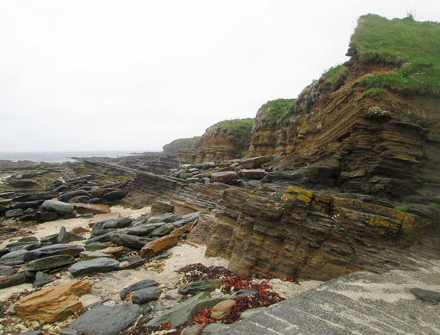
Skara Brae (see previous posts) lies beside the Bay of Skaill which has a lovely scenic beach.
Beach from Skara Brae:-

Panorama of bay and beach:-

There was a colouration difference under the water here:-

Further along the beach we spotted a fairly picturesque ruined building, perhaps once a croft:-

The abandoned agricultural equipment in foreground bolsters that assumption:-

Further along still we found this fantastic rock formation, layers on layers of sediment:-

You can see the slabs lying in the foreground. Lots of buildings in Orkney seemed to be made from slabs of stone like this.
No Comments »
