Canal Basin, Bowling
Posted in Scenery at 12:00 on 20 February 2025
The end/beginning of the Forth and Clyde Canal.

Canal basin from old railway bridge:-

River Clyde beyond. (Bowling harbour to upper right):-

Boats:-

Posted in Scenery at 12:00 on 20 February 2025
The end/beginning of the Forth and Clyde Canal.
Canal basin from old railway bridge:-
River Clyde beyond. (Bowling harbour to upper right):-
Boats:-
Posted in Architecture, Scenery at 12:00 on 23 October 2023
We travelled on from Comrie by way of a misty Loch Earn:-

On the way back via Innerpeffray Chapel we then sought out Tullibardine Chapel, a property in Perth and Kinross in the care of Historic Scotland. It’s located slightly northwest of Auchterarder:-

North gable end:-

View from east:-
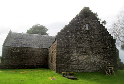
From south(ish.) Stitch of two photos:-

At first we thought the chapel wasn’t open but the door in the photo below was slightly ajar:-

Information board:-

Posted in Scenery, Scotland at 12:00 on 31 May 2023
Balmaha is a village on the eastern shores of Loch Lomond. I remember the Maid of the Loch used to call there on its trips up and down the loch back in the day.
The Loch from Balmaha:-

Boats on the loch:-

Present day pier:-

Looking south from pier:-

Loch inlet at Balmaha:-

Posted in Architecture, History, Scenery, Trips at 15:00 on 23 January 2023
Cairn’s entrance ladder:-

Entrance from inside. You can see it’s quite restricted. The woman in the picture was our travelling companion:-

There is some graffiti on the walls.
Interior side wall (i):-

Interior side wall (ii):-

Close up on graffiti:-

Original entrance from inside:-

Chambers:-


The side of Wideford Hill where the chamber sits overlooks an inlet of the NorthSea/Atlantic called the Bay of Firth. The settlement of Finstown lies to the far left of the Firth, beyond the islands as seen in this photo stitch:-

Posted in History, Scenery, Seaside Scenes, Trips at 12:00 on 21 January 2023
Wideford Hill Chambered Cairn, Orkney was one of the ancient sites in the Orkney Islands we didn’t visit in 2017. We tyook it in in June last year.
The approach is up a very steep – and winding – farm road till you reach the car park (grandiose description for two parking spaces) from which you can look down to Kirkwall. The photo also shows some of the road:-

There is a view of Scapa Flow from there too:-

A notice at the car park said the chambered cairn was about half a mile away on a path round the hill. It was much longer than that.
You can see me walking the path here in a photo taken by the good lady. As you can see the cairn is nowhere in sight and we had been walking for about twenty minutes by this time:-

Cairn from path. To the left you can see the box in which the key to the entrance is kept and the information board:-

Information board:-

Original entrance (now gridded off):-

Cairn from above. The modern entrance is the blue square on its top

Posted in Seaside Scenes, Trips at 12:00 on 2 January 2023
The previous time we visited the Brough of Birsay see here and here, the rain started to come in horizontally so we cut things short.
In June this year the weather was much more amenable.
On the way up we had stopped off at Marwick Head again.
Hoy from Marwick Head, Old man of Hoy just visible poking up at right hand end of island:-

Marwick Head from Brough of Birsay, Kitchener Memorial standing out on Marwick Head:-

Mainland Orkney from Brough of Birsay:-

Viking ruins lie close to the causeway from the mainland:-


This time we were able to stroll to the lighthouse:-
Stevenson Lighthouse, Brough of Birsay from path across the brough:-

Close up:-

From northwest:-

From South:-

Posted in Events dear boy. Events, History at 20:30 on 13 September 2022
When I discovered the late Queen’s cortege would be passing within twelve or so miles of my home on its way from Balmoral to Edinburgh I thought this is a bit of history (before her no monarch had died in Scotland since the father of Mary Queen of Scots) so we might as well go and see it. Something to tell the grandkid(s.) It would be the closest I’ll ever get to a reigning sovereign after all.
At first we tried to stand behind a crash barrier by the M 90 near Milnathort, Perth and Kinross, but a policewoman moved us on so we ended up on a motorway bridge. It wasn’t a good vantage point.
I did get a reasonable shot of the cortege approaching (the West Lomond Hill is in the background):-

However the close up I tried to get was too blurry. (The hearse was travelling at speed.)
I hurried to the other side of the bridge to snap this, which ended up very badly focused.

The convoy was actually quite large. This shows its tail end:-

It struck me when I downloaded it off the camera that it was fairly appropriate, though, as she was by that time gone. Elizabeth Alexandra Mary Windsor slipping inexorably into history (at 70 miles an hour.)
Posted in Bridges, Fife, Scenery at 12:00 on 22 April 2021
Last August there was severe flooding in Balbirnie Park. The Back Burn even overflowed by Balbirnie Golf Club’s eighteenth green, probably due to that tree trunk stuck at the bridge. Part of the revetments had been washed away:-


Between Golf Club’s clubhouse and Balbirnie House Hotel the road was flooded:-
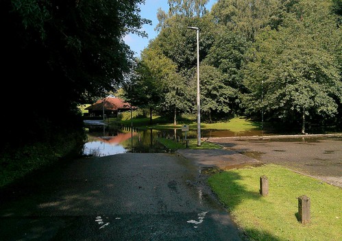
The area just at Balbirnie House (and Hotel) which had flooded in February 2020 did so again:-


Posted in Dumbarton, Trips at 12:00 on 7 March 2021
Luss is a village on the shores of Loch Lomond in the west of Scotland. It’s about twelve or so miles from Dumbarton.
It was the village where most of the outside shots for the Scottish Television (STV) soap opera Take the High Road were filmed.
Luss from the village pier:-

Part of Luss from the other side of the pier:-

Luss Church:-

In the churchyard there is a Viking hogback stone:-

Just up from the church there is this curious bridge which seems to cross a small inlet of Loch Lomond:-


In the village itself there’s this cottage with (shallow) cat slide dormer windows:-

The Loch Lomond Arms is at the top of the road down to the pier:-

Posted in Bridges, Fife at 12:00 on 25 February 2021
Abut a year ago we decided to take a walk to try to find the Barrel Brig, an old bridge over the River Ore in Fife. It had been featured in a calendar we had of local scenes but we’d never seen it.
It’s not on the beaten track and we had to walk quite a distance from where we parked in Coaltown of Balgonie. The start of the path has a view over to Balgonie Castle (on the left of this photo):-

It turned out to be a longer walk than we had expected along muddy roads/paths and over a disused railway line before finally seeing the River:-

It was still a couple of hundred metres or so before we saw the brig itself:-

The path curves round to the brig:-

You can see it’s not a modern thoroughfare:-

Before taking that shot I did scout down to the bank to grab this photo:-

We then strolled across the (unparapeted) bridge to get the opposite angle:-

On the way back to the car I took this shot over the fields to Largo Law in the distance:-

