Posted in Bridges, Norway Cruise, Trips at 12:00 on 2 October 2017
The Norwegians have invested their oil extraction revenues into a fund that benefits every Norwegian. In addition they have built roads through their country, tunnelling through the mountains from fjord to fjord.
Not to mention bridges across the narrowest point of some fjords like this elegant one across Lysefjord:-

Closer view:-

From below:-

There’s a solid rock mountain at one end of the bridge necessitating a sharp right turn (or left turn if you’re coming the other way):-

Reverse view:-

Edited to add:- there are some more photpgraphs of the bridge here. looking at the one on the right hand-side of the page it seems you can turn right or left (through a tunnel) at the cliff end of the bridge; which wasn’t obvious from fjord level.
No Comments »
Posted in Norway Cruise, Trips at 12:00 on 28 September 2017
From the deck of the MV Black Watch I spotted electric cables and pylons and thought the wires were going up the side of the fjord.
No.
In Norway they think nothing of stringing cables right across the fjords:-


They dip quite low:-

Cables and anchor points:-

A more typical fjord sight. A waterfall:-

At first, being a habitual user of the SI system of units, I read this as, “Distance to horizon 7 nanometres”:-

Then I remembered we were on a ship. “7 nautical miles.”
No Comments »
Posted in Norway Cruise, Trips at 12:00 on 27 September 2017
Lysefjord contains two natural features which are tourist attractions. One is the Kjerag Boulder, a 5 m3 rock left stuck between two pieces of mountain by retreating ice.
From the MV Black Watch it was not really apparent photographically:-

Close-up. It’s that little dot between the two rocks in the middle of the photo:-

People go and stand on this thing!:-
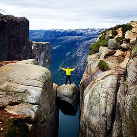
(By Scoundrelgeo – Own work, CC BY-SA 4.0, https://commons.wikimedia.org/w/index.php?curid=41795395)
The other feature is known as Pulpit Rock becasue of its shape. The top is 604 metres above the fjord’s surface. You’ll note from the photo in the link that there are no railings around the top of this even though people go to visit – and stand on it. The Norwegian Government says, quite reasonably, that it cannot fence off every piece of nature in the country.
From distance:-

Closer view:-

Showing pulpit shape:-

No Comments »
Posted in Norway Cruise, Trips at 12:00 on 26 September 2017
Thought I’d better post a few photos of a fjord.
The first one we visited was Lysefjord in Rogaland County, Norway.
Looking back towards fjord entrance:-
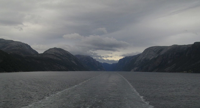
Looking up fjord:-

Mountain and waterfall:-

The Norwegians exploit any green spaces they can find or create. Most of these houses are only accessible by boat and are used as summer residences:-

No Comments »
